PAKISTAN
 DOWNLOADS
Provinces of pakistan
History of Lahore
Feed Back
Pakistan
Islam
Cooking
E-Cards
Latest News
Music Videos
Dating And Matrimonial
Audio Music
SMS TO ALL PAKISTAN
WALLPAPERS
LIVE WEB TV
DOWNLOADS
Provinces of pakistan
History of Lahore
Feed Back
Pakistan
Islam
Cooking
E-Cards
Latest News
Music Videos
Dating And Matrimonial
Audio Music
SMS TO ALL PAKISTAN
WALLPAPERS
LIVE WEB TV
A BRIEF INTRODUCTION OF PAKISTAN
.Pakistan displays some of Asia’s most magnificent landscapes as it stretches from the Arabian Sea, its southern border, to some of the world’s most spectacular mountain ranges in the north.
Pakistan is also home to several awe inspiring archeological sites that date back to word’s earliest civilizations or settlements rivaling those of ancient Egypt and Mesopotamia.
GANDHARA
Gandhara region was once the cradle of Buddhism. The archaeological remains found in Taxila, Peshawar, Charsadda, Takht Bhai, Swat and rock carvings along the ancient Silk Road (KKH) provide fascinating records of the history of Gandhara, a civilization 3000+ years ago. The sculptures, cultural artifacts and other relics of this ancient civilization are well known around the world. Taxila attracted the attention of the great conqueror, Alexander in 327 BC, when it was a province of the powerful Achaemenian Empire. It later became part of the Maurian dynasty and underwent remarkable development under the great Ashoka. For a long time Taxila, Peshawar and Swat were renowned centers of learning philosophy, art and trade. Pilgrims and travelers were attracted to Gandhara from as far as China and Greece.
Geografy
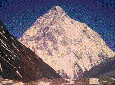
Stretching in the North, from east to west, are a series of high mountain ranges which include the Himalayas, the Karakoram and the Hindukush - three of the mightiest mountain systems of the world. With the assemblage of 35 giant peaks over 24,000 ft. high (7,315m), the region is the mountaineers’ paradise. Pakistan has seven of the 16 tallest peaks in Asia. Forty (40) of the world's 50 highest mountains are in Pakistan. Nowhere else in the world is such a great concentration of high mountains, peaks, glaciers and passes. K-2 (8611m), the second highest peak in the world is also located in Pakistan. The local name of K-2 (picture above) is Chogori, which in Balti language means the king of mountains. By all accounts, K-2 presents a more formidable mountaineering challenge than the Everest. Nanga Parbat (8125m), also known as the "Killer Mountain", is the second highest peak in Pakistan. Its name literally means "Naked Mountain."
PAKISTAN FACT SHEET
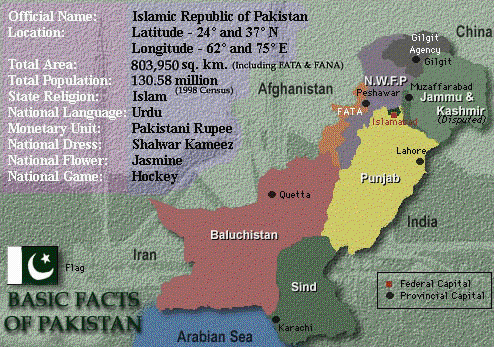
Official NameIslamic Republic of PakistanCapitalIslamabadArea796,095 Sq. km.Population135.28 millionEthnic composition95% Muslims, 5% othersPer capita incomeUS$ 460CurrencyPak RupeeExportsCotton, textile goods, rice, leather items carpets, sports goods, fruits, handicrafts Sea Food (Fisheries)ImportsIndustrial equipment, vehicles, iron ore, petroleum, edible oilLanguagesUrdu (National language) - English (Official)Literacy rate38.9%GovernmentParliamentary form - Two Houses i.e., the Senate (Upper House) and the National Assembly (Lower House).Pakistan National FlagDark green with a white vertical bar, a white crescent and a five-pointed star in the middle. The Flag symbolizes Pakistan's profound commitment to Islam and Islamic world.National FlowerJasmineFloraPine, Oak, Poplar, Deodar, Maple, MulberryFaunaThe Pheasant, Leopard, Deer, Ibex, Chinkara, Black buk, Neelgai, Markhor, Marcopolo sheep, Green turtles, River & Sea fish, Crocodile, Water FowlsPopular gamesCricket, Hockey, FootballTourist's resortsMurree, Quetta, Hunza, Ziarat, Swat, Kaghan, Chitral and GilgitArchaeological sitesMoenjo Daro, Harappa, Taxila, Kot Diji, Mehr GarhMajor CitiesIslamabad, Karachi, Lahore, Peshawar, Quetta, Rawalpindi, Hyderabad, Multan, Sialkot and FaisalabadAgricultureMajor crops are cotton, wheat, rice and sugarcaneIndustryTextiles, cement, fertiliser, steel, sugar, electric goods, shipbuildingEnergyMajor sources: Oil, Coal, Hydel, Thermal, Nuclear and Liquid Petroleum GasFamous Mountain PeaksK-2 (Mt. Godwin Austin): 28,250 ft./8611 m (2nd in World) Nanga Parbat : 26,660 ft./8126 m (8th in World) Gasherbrum-I: 26,470 ft./8068 m (11th in World)Famous Mountain PassesThe Khyber Pass The Kurram Pass The Tochi Pass The Gomal Pass The Bolan Pass The Lowari Pass The Khunjrab PassRiversThe Indus2896 kmJhelum825 kmChenab1242 kmRavi901 kmSutlej1551 kmBeas (tributary of Sutlej)398 kmFamous GlaciersSiachin75 kmBatura55 kmBaltoro62 kmDesertsThar: Sindh Cholistan: Punjab Thal: PunjabLakesMancharSindhKeenjarSindhHannaBalochistanSaif-ul-MalukNWFPSatparaNorthern AreasKachuraNorthern AreasMajor DamsMangla DamPunjabTarbela DamNorth West Frontier ProvinceWarsak DamNorth West Frontier Province
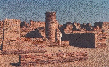
indus civilization
The Indus Valley Civilization was at its peak from the 3rd to the middle of the 2nd millennium BC. Moenjodaro was once a metropolis of great importance, forming part of the Indus Valley Civilization with Harrappa, Kot Diji and Mehr Garh. Moenjodaro, one of the most spectacular ancient cities of the world, had mud and baked brick buildings, an elaborate covered drainage system, a large state granary, a spacious pillared hall, a college of priests, a palace and a citadel. Harrappa, another major city of the Indus Valley Civilization, was surrounded by a massive brick wall fortification. Other features and plan of the city were similar to that of Moenjodaro. The Kot Diji culture is marked by fascinating pottery and houses built of mud-bricks and stone foundations. Mehr Garh, the oldest town (7000 B.C) shows evidence of crop cultivation, animal husbandry and human settlements. The inhabitants of Mehr Garh lived in mud-brick houses and learned to make pottery around 6,000 B.C
climate
Although the country is in the monsoon region, it is arid, except for the southern slopes of the Himalayas and the sub-Mountainous tract. The four seasons in Pakistan are:
(i) Winter (December to March).
(ii) Spring-Summer (April to June).
(iii) Summer-Monsoon season (July to September).
(iv) Post-Monsoon Fall (October and November).
DOWNLOADS
Provinces of pakistan
History of Lahore
Feed Back
Pakistan
Islam
Cooking
E-Cards
Latest News
Music Videos
Dating And Matrimonial
Audio Music
SMS TO ALL PAKISTAN
WALLPAPERS
LIVE WEB TV
A BRIEF INTRODUCTION OF PAKISTAN
.Pakistan displays some of Asia’s most magnificent landscapes as it stretches from the Arabian Sea, its southern border, to some of the world’s most spectacular mountain ranges in the north.
Pakistan is also home to several awe inspiring archeological sites that date back to word’s earliest civilizations or settlements rivaling those of ancient Egypt and Mesopotamia.
Pakistan is also home to several awe inspiring archeological sites that date back to word’s earliest civilizations or settlements rivaling those of ancient Egypt and Mesopotamia.
GANDHARA
Gandhara region was once the cradle of Buddhism. The archaeological remains found in Taxila, Peshawar, Charsadda, Takht Bhai, Swat and rock carvings along the ancient Silk Road (KKH) provide fascinating records of the history of Gandhara, a civilization 3000+ years ago. The sculptures, cultural artifacts and other relics of this ancient civilization are well known around the world. Taxila attracted the attention of the great conqueror, Alexander in 327 BC, when it was a province of the powerful Achaemenian Empire. It later became part of the Maurian dynasty and underwent remarkable development under the great Ashoka. For a long time Taxila, Peshawar and Swat were renowned centers of learning philosophy, art and trade. Pilgrims and travelers were attracted to Gandhara from as far as China and Greece.
Geografy
Stretching in the North, from east to west, are a series of high mountain ranges which include the Himalayas, the Karakoram and the Hindukush - three of the mightiest mountain systems of the world. With the assemblage of 35 giant peaks over 24,000 ft. high (7,315m), the region is the mountaineers’ paradise. Pakistan has seven of the 16 tallest peaks in Asia. Forty (40) of the world's 50 highest mountains are in Pakistan. Nowhere else in the world is such a great concentration of high mountains, peaks, glaciers and passes. K-2 (8611m), the second highest peak in the world is also located in Pakistan. The local name of K-2 (picture above) is Chogori, which in Balti language means the king of mountains. By all accounts, K-2 presents a more formidable mountaineering challenge than the Everest. Nanga Parbat (8125m), also known as the "Killer Mountain", is the second highest peak in Pakistan. Its name literally means "Naked Mountain."
PAKISTAN FACT SHEET
Official NameIslamic Republic of PakistanCapitalIslamabadArea796,095 Sq. km.Population135.28 millionEthnic composition95% Muslims, 5% othersPer capita incomeUS$ 460CurrencyPak RupeeExportsCotton, textile goods, rice, leather items carpets, sports goods, fruits, handicrafts Sea Food (Fisheries)ImportsIndustrial equipment, vehicles, iron ore, petroleum, edible oilLanguagesUrdu (National language) - English (Official)Literacy rate38.9%GovernmentParliamentary form - Two Houses i.e., the Senate (Upper House) and the National Assembly (Lower House).Pakistan National FlagDark green with a white vertical bar, a white crescent and a five-pointed star in the middle. The Flag symbolizes Pakistan's profound commitment to Islam and Islamic world.National FlowerJasmineFloraPine, Oak, Poplar, Deodar, Maple, MulberryFaunaThe Pheasant, Leopard, Deer, Ibex, Chinkara, Black buk, Neelgai, Markhor, Marcopolo sheep, Green turtles, River & Sea fish, Crocodile, Water FowlsPopular gamesCricket, Hockey, FootballTourist's resortsMurree, Quetta, Hunza, Ziarat, Swat, Kaghan, Chitral and GilgitArchaeological sitesMoenjo Daro, Harappa, Taxila, Kot Diji, Mehr GarhMajor CitiesIslamabad, Karachi, Lahore, Peshawar, Quetta, Rawalpindi, Hyderabad, Multan, Sialkot and FaisalabadAgricultureMajor crops are cotton, wheat, rice and sugarcaneIndustryTextiles, cement, fertiliser, steel, sugar, electric goods, shipbuildingEnergyMajor sources: Oil, Coal, Hydel, Thermal, Nuclear and Liquid Petroleum GasFamous Mountain PeaksK-2 (Mt. Godwin Austin): 28,250 ft./8611 m (2nd in World) Nanga Parbat : 26,660 ft./8126 m (8th in World) Gasherbrum-I: 26,470 ft./8068 m (11th in World)Famous Mountain PassesThe Khyber Pass The Kurram Pass The Tochi Pass The Gomal Pass The Bolan Pass The Lowari Pass The Khunjrab PassRiversThe Indus2896 kmJhelum825 kmChenab1242 kmRavi901 kmSutlej1551 kmBeas (tributary of Sutlej)398 kmFamous GlaciersSiachin75 kmBatura55 kmBaltoro62 kmDesertsThar: Sindh Cholistan: Punjab Thal: PunjabLakesMancharSindhKeenjarSindhHannaBalochistanSaif-ul-MalukNWFPSatparaNorthern AreasKachuraNorthern AreasMajor DamsMangla DamPunjabTarbela DamNorth West Frontier ProvinceWarsak DamNorth West Frontier Province
indus civilization
The Indus Valley Civilization was at its peak from the 3rd to the middle of the 2nd millennium BC. Moenjodaro was once a metropolis of great importance, forming part of the Indus Valley Civilization with Harrappa, Kot Diji and Mehr Garh. Moenjodaro, one of the most spectacular ancient cities of the world, had mud and baked brick buildings, an elaborate covered drainage system, a large state granary, a spacious pillared hall, a college of priests, a palace and a citadel. Harrappa, another major city of the Indus Valley Civilization, was surrounded by a massive brick wall fortification. Other features and plan of the city were similar to that of Moenjodaro. The Kot Diji culture is marked by fascinating pottery and houses built of mud-bricks and stone foundations. Mehr Garh, the oldest town (7000 B.C) shows evidence of crop cultivation, animal husbandry and human settlements. The inhabitants of Mehr Garh lived in mud-brick houses and learned to make pottery around 6,000 B.C
climate
Although the country is in the monsoon region, it is arid, except for the southern slopes of the Himalayas and the sub-Mountainous tract. The four seasons in Pakistan are:
(i) Winter (December to March).
(ii) Spring-Summer (April to June).
(iii) Summer-Monsoon season (July to September).
(iv) Post-Monsoon Fall (October and November).
(i) Winter (December to March).
(ii) Spring-Summer (April to June).
(iii) Summer-Monsoon season (July to September).
(iv) Post-Monsoon Fall (October and November).